Thursday, March 13, 2008
खानदेश दर्शन
Maharashtra has a glorious history. It is a holy land of saints, sages and social reformers. Peasants and workers have toiled for centuries to make Maharashtra the Prime State of India.
The State is spread over an area of 308,000 square kilometres. It is divided into six administrative divisions and 35 districts. Mumbai, the capital of the State, is also the Financial Capital of India.
According to the World Bank Survey, Maharashtra has the most favourable atmosphere among the States in the country, for industrial investment, domestic and foreign. This was endorsed at an Infrastructure Conference held in Mumbai in November 2002 once again. No wonder, Maharashtra has been leading the list of all the States as far as the investment flow is concerned and is poised to guide the country in the infrastructure development sector.
To keep up with the modern transformations around the globe, Maharashtra has achieved the leading position amongst all other States in the field of Information Technology and occupies numero-uno position in the country in setting up IT Parks and in adopting a Bio-Tech Policy in a determined bid to compete with other countries of the world.
It was in Ahmednagar district of Maharashtra that the first cooperative sugar factory in Asia was established. Employment Guarantee Scheme, popularly known as EGS, has been providing employment to the weaker sections of society in times of distress for the past three decades. The genesis of this revolutionary concept can be found in Maharashtra’s rich cultural and social heritage. A similar scheme, launched by the Government of India, is based on EGS.
Maharashtra also ushered the road construction industry in India into the 21st century. The Mumbai-Pune Expressway is the testimony of this achievement. This is the first superway in the country on which vehicles can ply safely at 100 km and the concept is now replicated all over India.
The State has achieved remarkable progress in administrative reforms. The law and order situation in the State is the best in the country. Setting up of maiden Cyber Crime Cell in Western India has added another feather in its cap of police force. Maharashtra has earned the distinction of implementing the Western practice of Tourism Police for the first time in the country.
This is the land, which gave birth to father of Indian film industry, Shri Dadasaheb Phalke. Just a few years ago, Dr. Vijay Bhatkar made the whole world sit up and take Maharashtra’s notice by producing PARAM super computer within minimum time and funds. Cricket lovers across the world are mesmerised by the scintillating batting of Sachin Tendulkar, who is a quintessential Mumbai product. Ashutosh Gowarikar, nominated for Oscar by Hollywood, learnt the film craft in Mumbai.
Marathi stage and its path-breaking drama production, nearly 500 Diwali Special Numbers to salute Marathi every year and Ganpati festival, the largest public celebration in the world, are only a few distinctive features of the State.
Mango, orange, grape or pomegranate produced in the State have been adorning shelfs in the department stores across the world for years. Moreover, a food and agro-produce processing industry is developing in various corners of the State now. Maharashtra’s performance in diverse fields like arts, sports, culture, literature, social and administrative reforms as well as academics research, defence and agriculture has left its unique mark in India. Its many great personalities reached the pinnacles of achievements in the respective fields of activity. The social reforms movement in the State began over 150 years ago. It has been the source of inspiration for the country. Maharashtra is known for bravery of its people who blend it with tolerance. The socially amicable atmosphere in Maharashtra surprises people from other states of India for these reasons.
MAHARASHTRA
1. Districts : 35
2. Area : 308,000 sq. kms.
3. Sub-Divisions : 109
4. Talukas : 353
5. Municipal Corporations : 19
6. Municipal Councils : 224
7. Zilla Parishads : 33
8. Panchayat Samitis : 349
9. Gram Panchayats : 27832
(Including Nagar Panchayats)
10. Means of Transport : Roads- 2,16,968 kms.
NH-3710
SH-32586
Main District Roads-45543
Other Roads -43511
Rural Roads -91618
Railways-5459 kms.
Broad gauge -4153
Meter gauge -300
Narrow gauge -806
Ports –50
Main Ports -2
Small Ports -48
Others
Post Offices -12788
Rural-11394
Urban-1394
Telephones - 54.58 lakh
Internet Connections-3,50,000
(NH= National Highway)
(SH= State Highway)
10. Population : Total - 9,67,52,247
(Provisional 2001) Male-5,03,34,270
Female-4,64,17,977
Male-Female Ratio-922 (per
thousand)
Children (Age 0-6) - 1,31,87,087
Boys- 68,78,579
Girls- 63,08,508
12. Literacy Rate : Per cent-77.3
Total- 6,45,66,781
Male- 3,74,87,129
Female- 2,70,79,652
13. Area under Irrigation : 29.8 lakh hectares
14. Irrigation Projects : Major-31
(as on 30-6-2002) Medium-176
Minor-2150
15. Industries : 33626 (Registered)
(2000-2001)
16. Tourist Places : Gateway of India, Juhu Beach, Goregaon Film City, Kanheri Caves, Lonavla and Khandala, Matheran, Shreekshetra Ganpatipule, Sindhudurg and Vijaydurg forts, Trimbkeshwar, Saptashirngi Hill, Jyotirlinga, Palace of Chandbibi (Ahmednagar), Shirdi Saibaba, Mahableshwar and Panchgani, Koynanagar, Pandharpur, Ajanta and Ellora Caves, Chikhaldara, Sachkhand Gurudwara at Nanded, Tuljapur, Sahastrakund Waterfalls near Umerkhed, Sewagram, Paunar; Botanical Park and Deekshabhoomi at Nagpur
(For details refer District-wise
information)
17. Languages/Dialects : Marathi is the principal language of Mahrashtra. In the north-west parts, a mixture of Gujarati and Dangi is spoken. Marathi in north Maharashtra is a mixture of Hindi, Malvi, Bundeli and has some influence of Ahirani. Marathi in south-east and south is influenced by Telugu and Kannada. Of the total population of the State, 73 per cent is Marathi-speaking. Hindi (8 per cent), Urdu (7 per cent) and Gujarati (3 per cent) are the other major languages.
18. Folk-Arts : See District-wise details
19. Weather : Four Seasons
Winter-Mid Sept. to Feb.
Summer-March to May
Monsoon-June to Sept.
Post Monsoon-Oct. to Mid Dec.
October is very warm.
20. Agriculture Production : Kharif Crops-
Jowar (Sorghum), Bajra (Millet), Rice, Cotton, Groundnuts
Rabi Crops - Wheat, Gram, Jowar
Cereals - Jowar, Rice, Wheat, Bajra, Maize, Bali, Nachni
Pulses –Dal, Tur (Red gram)
Cash Crops -Sugarcane, Cotton, Chillies, Tobacco, Banana.
Oil seeds- Groundnut, Sesame, Jawas, Karadi, Mustard.
21. Net Crop Area : 17,619,000 hectares
Total Crop Area : 22,381,000 hectares
Total Irrigated Area : 3,667,000 hectares
Ratio of Total Irrigated
Area with Crop Area : 16.4 per cent
22. Area under Cereals : 9,411,000 hectares
Area under Pulses : 33,88,000 hectares
Total AreaunderFood-grains :798,000 hectares
23. Area under Horticulture : 10.14 lakh hectares (as on 15-11-02)
24. Health Infrastructure : PHCs - 1768
Dispensaries - 1544
Hospitals - 1102
Sub-Centres - 9725
(PHCs=Primary Health
Centres)
25. Educational Institutions : Universities - 20
Colleges - 1708
Prim. Schools - 68736
Sec. Schools- 16647 (including
Higher Secondary)
----------------------------------------------------------------------------------------
http://www.maharashtra.gov.in/pdf/gazeetter_reprint/Khandesh/gen_geology.html#3Position and Area.
Kha'ndesh, [According to Abul Fazl (Gladwin's Ain-i-Akbari, II। 57), the name Khandesh is derived from Khan the title given (1417) by Ahmed I। of Gujarat (1411-1443) to Malik Nasir the second of the Faruki kings (Briggs' Ferishta, IV. 293). The fact that Ferishta (Briggs, I. 307 - 309) speaks of the chiefs of Khandesh in his account of the first Musalman conquest (1294), favours the view that the name was older than Musalman times, and was possibly changed by them to suit the title of the Faruki kings. Mr, Sinclair, (C.S., has suggested (Ind. Ant. IV. 108) Kanhadesh or the land of Krishna, as the original form. According to some old verses Khandesh is the Khandav forest of the Mahabharat (Rao Saheb K. B. Marathe, Subordinate Judge of Amalner); and Wilson (Mahabharat List of Peoples and Places: Works, VII. 164) mentions the Khandas or Shandas next before the people of Vidarbha or Bedar. Col. Sykes (Rep. Brit. As. 1837! 237) derives the name from khand or khind, a gap or mountain pass.] lying between 20° 8' and 22° 7' north latitude and 73° 42' and 76° 28' east longitude, with a total area of 10,431 square miles, had, in 1872, a population of 1,028,642 souls or ninety-eight to the square mile, and in 1879, a land revenue of £310,069 (Es. 31,00,690).
Boundaries.
Stretching nearly 160 miles along the Tapti, and varying in breadth from seventy to ninety miles, Khandesh forms an upland basin, the most northerly section of the Deccan table-land। Along the whole northern frontier, the district is bounded by the Satpuda range, a mountain tract from thirty to forty miles wide. From the north-east corner, as far as the Sindva pass on the Agra road, except two or three of the southern ridges, the hill country belongs to His Highness Holkar. Further west, in Shahada, the Khandesh boundary skirts the base of the hills; then, including the Akrani territory, it strikes north, right into the heart of the hills, to where, in a deep narrow channel, the Narbada forces its way through the Satpudas. From this to its north-west corner, the Narbada remains the northern boundary of the district. On the east and south-east, a row of pillars and some convenient streams, without any marked natural boundary, separate Khndesh from the Central Provinces and Berar. To the south the Ajanta, Satmala or Chandor range may roughly be said to mark the line between Khandesh and the Nizam's territory. On-the south-west, the Arva or Laling, and Galna hills separate Khandesh from Nasik. Thence the frontier crosses the Sahyadris, and runs north-west along a well marked western spur of that range, as far as the town and fort of Songad. From Songad the Tapti river and a line of masonry pillars carry the boundary north-east back to the Satpudas at the west end of the Akram territory. Within these limits, except that in several places along the south boundary the Nizam's territory runs north of the Ajanta range, and that in the extreme south a group of thirteen Khandesh villages lies isolated on the Deccan table-land, Khandesh is a compact district with none of its lands subject to any other jurisdiction.
Aspect.
An upland basin, draining into the Tapti with a gentle westerly slope, Khandesh includes most varied tracts of country, wild hill and forest, rich garden and grove, stretches of barren plain, and low rolling rocky hills. From east to west, parallel with the Tapti, are three well marked belts of country, in the centre the rich Tapti valley, in the north the high and wild Satpudas, and in the south and south-west bare ridges and rich well watered valleys flanked by the Ajanta and Sahyadri hills.
The Tapti banks are high and bare, and the land on both sides is seamed by tributary rivers and streams. Now and again from the north, spurs of the Satpudas stretch close to the river bank, and on the south rise some low barren hill ranges. With these exceptions, the long central plain is, for about 150 miles from Burhanpur to Nandurbar, an unbroken stretch of deep alluvial soil The east and centre are rich and well tilled. The towns and illages are large and prosperous, surrounded by mango groves and gardens, and except when baked by the raging winds of the hot season, the fields are green with varied tillage. On both sides of the river cultivation is widespread. Southward it stretches to the higher soils and barren hill sides, and north to the line of deep forest that clothes the base of the Satpudas. In the west, though the soil is no less rich, parts of Nandurbar, Shahada, and Taloda are overgrown with forest and brushwood, the climate is unhealthy, and the people are few and poor.
North Belt.
North of the Tapti, the whole length of the rich alluvial plain is bounded by the steep southern face of the Satpudas, a belt of mountain land from twenty to thirty miles broad. Much of this hill country, now with only a few scattered Bhil hamlets, was once well peopled. At every few miles in the forest of Pal Tappa are ruins of villages with remains of sugar and oil mills. Further west, Amba, in the wide valleys of the Aner and the Arunavati, is dotted with the brushwood-covered ruins of the temples, mosques, wells, and upper-storied houses of what must once have been considerable towns. Though so much is deserted, in the north-west the cool waving Akrani uplands are well tilled and prosperous, peopled by Pavras, skilful and hardworking peasants, whose homesteads, each in its plot of fields, are sheltered by well kept mango and moha, Bassia latifolia, groves.
South Belt.
South of the rich Tapti valley, the country is more varied than either in the centre or in the north. In the extreme east, the Purna valley, between the Hatti hills on the east and rolling broken ground on the west, stretches south, much of it, from the fear of wild beasts, waste or covered with brushwood Further west, drained by the Vaghur, the Girna, and the Bori, wide stony thorny plains rise in low broad-topped basaltic ridges, or sink in rich valleys studded with mango groves and large prosperous villages. West of the Bori, the land, as it draws nearer the Sahyadris, grows wilder and more picturesque. Ranges of quaintly cut hills, separated by the rich well watered valleys of the Panjhra, the Kan, and the Borai, stretch far east across the Khandesh plain. The extreme west is wild and hilly; the air, though cool and pleasant, is, except in the hot season, laden with fever; the people are poor and unsettled ; and the hill sides, bare in the east and well wooded in the west, yield only scanty crops of coarse grain.
Down the western Sahyadri slopes the district stretches into the Daugs, a broken tract crossed by endless lines of -petty hills, much of it forest, with a deadly climate, a poor and wretched people, and the rudest tillage.
Climate.
The Khandesh seasons are the rainy months from the middle of June to the middle of October, the cold months from the middle of October to the middle of February, and the hot months from the middle of February to the middle of June. From variety of height, position, and character, the climate varies greatly in different parts of the district. In the,western hills and forests, the rainfall from the south-west monsoon is heavy, and in the Satpudas the supply is also considerable. But over much of the centre and south the fall is scanty and uncertain, and in few seasons it is in all parts sufficient. Throughout Khandesh it is less than in the Southern Maratha Country, and little if at all greater than in the Deccan. Dhulia, removed from the extremes of scarce and of abundant rainfall, had, during the twenty-nine years ending 1879, an average supply of 21.78 inches, the amount varying from 10.94 in 1871 to 35.92 in 1878. The following table gives, the yearly returns:
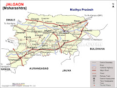
Jalgon District
Jalgaon district is known for its advances in horticulture. Its production of bananas and cotton, especially by resorting to drip irrigation, has created a role model for cultivators in other parts of India. Bananas grown in the district are exported outside the State and to other countries. Mehrun village is famous for its unique bor (jubjube). Amalner is regarded as Pandharpur of Khandesh. Centuries ago, Sant Muktabai’s stay in the district has made it a holy place since. In present times, legendary poetess Bahinabai Chaudhari of Jalgaon spread the fame of the Ahirani dialect across the seven seas. Sane Guruji awakened the labour class while Balkavi Thomre’s poetry enriched socio-cultural life of the district.
1. District: Jalgaon
2. Area: 11757 sq. kms.
3. Sub-divisions :
4 (Jalgaon, Bhusawal, Pachora, Amalner)
4. Talukas:
15 (Jalgaon, Bhusawal, Jamner, Edlabad, Raver, Yaval,
Chopda, Amalner, Parola, Pachora,
Chalisgaon, Erandol, Bhadgaon, Bodwad, Dharangaon)
5. Distance from Mumbai: 420 kms.
6. Means of Transport
Main Airport- Jalgaon
Railway Stations -CR and WR , ST Buses
7. Population :
Total-36,79,936
Male-19,04,437
Female-17,75,499
8. Literacy:
Per cent-76.06
Total-24,09,853
Male-14,10,865
Female-9,98,988
9. Area under Irrigation : 1,21,000 hectares
10. Irrigation Projects : Major-2 , Medium-10, Minor-514
Imp. Projs.-2: 1. Upper Tapi , 2. Hatnur
11. Industries : Big-63 , Medium-128 , Small-3303
12. Languages/Dialects: Ahirani, Marathi
13. Folk-Arts :Lavani, Tamasha, Gondhal
14. Weather :
Temperature- Max.-34.9 Deg. C. Min.-19.9 Deg. C. Rainfall-763.6 mm (Average)
15. Main Crops : Banana, cotton, sugarcane , oil seeds, pulses
16. Area under Horticulture 47424 hectares
17. Health Infrastructure:
PHCs-77
Rural Hosp.-15
Dist. Hosp.-1
Big Hosp.-27
18. Tourist Places : Pal hill station at Raver, Patnadevi temple Chalisgaon,
Muktabai temple at Kothali, Changdev temple at the
confluence of Tapi and Purna rivers; ancient Ganpati temple
at Erandol Padmalaya, hot water springs at Unapdev in Chopda
Taluka, ancient Mahadev temple at confluence of rivers Tapi,
Girana and Anjani at Rameshwar in Amalner taluka, mammoth yatra of
Sant Sakharam Maharaj at Amalner, Gandhi Philosophical Temple at Amalner
19. Educational Institutions
Universities-1
Colleges-54
Prim. Schools - 2057
Sec. Schools - 517
------------------------------------- xxx -------------------------------------
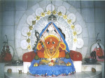
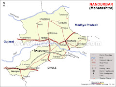
The Nandurbar district of Maharashtra holds a total area of 5034 sq km. The place accommodates 13, 09, 135 no. of people out of which 6, 10, 389 no. of people have access to literacy programmes. Blessed with high agricultural production, the lands of the district are utilized to grow rice, jowar, wheat, sugarcane, groundnuts, cotton, toor, among others. Two shipping mills and three sugar factories of Nandurbar provide occupation to most of the inhabitants. Sidheswar temple, sculpture of Mahavir, Dattatreya temple, Pandava Leni, Toranmal Shiv temple, Prakasha Dakshin Kashi, Hidimba's forest, Horaphali waterfall, Upandev, Narayanpur and Padalpur dominates the tourism landscape of Nandurbar.
A predominantly tribal pocket, which has been socially and politically alert, Nandurbar district has become internationally known for the first project of manufacturing particle boards from sugarcane baggasse in the world. Nandurbar is identified with Shirish Kumar, who scarified his life at a tender age during the freedom struggle. His Memorial is like a place of pilgrimage for many. Important crops of this district are chillies, cotton, sugarcane and tur. Almost 62 per cent population of this district is tribal. Adivasi Pawara dance and Songadya Party are its distinguished socio--cultural features. Toranmal hill station attracts tourists round the year.
1. District: Nandurbar
2. Area: 5035 sq. kms.
3. Sub-divisions: 2 (Nandurbar, Talode)
4. Talukas : 6 (Navapur, Nandurbar, Talode, Akkalkuva, Akrani, Shahada)
5. Distance from Mumbai 380 kms.
6. Means of Transport
Railway Stations –11
Total bus routes of Dhule
and Nandurbar -1024.
No. of ST Buses-681
7. Population
Total-13,09,135
Male-6,62,764
Female-6,46,371
8. Literacy
Per cent-56.06
Total-6,10,389
Male-3,65,266
Female-2,45,123
9. Area under Irrigation
47891 hectares
10. Irrigation Projects
Medium-1
Minor-29
11. Industries
Big-1
Medium-21
Small-344
12. Languages/Dialects
Marathi, Ahirani and Adivasi
13. Folk-Arts
Tribal Pawra dance, Songadya Party
14. Weather
Temperature-
Max.-34.1 Deg. C.
Min.-21.5 Deg. C.
Rainfall-767 mm (Average)
15. Main Crops
Kharif and Rabi jowar, maize, wheat, bajra, cotton, sugarcane,
rice, chillies, tur
16. Area under Horticulture : 7526 hectares
17. Health Infrastructure
PHCs-47
Dist. Hosp.-1
Govt. and Pvt. Hosp.-10
18. Tourist Places
Toranmal hill station in Akrani (Dhadgaon ) taluka, Gurudutt Temple at
Sarangkheda, Prakasha- famous as replica of Kashi,
Shanimandal-replica of Shanishingnapur
19. Educational Institutions
Colleges-40
Prim. Schools-1348
Sec. Schools- 204
------------------------------------- xxx -------------------------------------
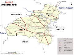
Dhule District
Famous for its pure milk, the district of Dhule is an important district of Maharashtra. It lies in the northern part of the state covering an area of 8061 square kilometers and has a population of 17,08,993. Dairy products and agriculture earns the maximum revenue for the district. Bajra, jowar, cotton, chillies and wheat are the main crops. Dhule takes pride in its fantastic tourism spots like Laling Fort, Nakane Tank, Maharaj Temple and several other places.
DHULE
Dhule district in general and the town in particular had been famous for its pure milk. Milch cattle used to be fed with cotton pend (cattlefeed made by using cotton extract), which would produce rich quality milk. Customers in Delhi once upon a time used to wait for the delivery of milk from Dhule. Dondaicha in this district is the only town in the State to produce glucose sugar and other products from maize. Laling fort, Tirupati Balaji temple of Shirpur, Nakane Pond, Rajwade Sanshodhan Mandir are places of tourists interest. Dhule district has been known for cash crops like, cotton and chillies.
1. District : Dhule
2. Area : 8061 sq. kms.
3. Sub-divisions : 2 (Dhule, Shirpur)
4. Talukas : 4 (Dhule, Shirpur, Sakri,
Sindkheda)
5. Distance from Mumbai : 360 kms.
6. Means of Transport : Railway Stations -12
(CR-5 and WR-7)
Road Transport
Bus routes-1024
No. of buses-681
7. Population. : Total-17,08,993
Male-8,78,538
Female-8,30,455
8. Literacy : Per cent-72.08
Total-10,54,979
Male-6,14,159
Female-4,40,820
9. Area under Irrigation : 51597 hectares
10. Irrigation Projects : Medium-11
11. Industries : Big-2
Medium-9
Small-132
12. Languages/Dialects : Marathi and Ahirani
13. Folk-Arts : Keertan, Tipari dance and tribal dance
14. Weather : Temperature-
Max.-35 Deg. C.
Min.-16 Deg. C.
Rainfall - 592 mm (Average)
15. Main Crops : Bajra, jowar, cotton, chillies, wheat, sugarcane
16. Area under Horticulture : 1813 hectares
17. Health Infrastructure : PHCs-36
Rural Hosp.-4
Dist. Hosp.-1
Cottage Hosp.-2
Govt. Med. Collg.-1
18. Tourist Places : Laling fort, Laling Kuran, replica of Tirupati Balaji Temple at Shirpur, several dams and Bijasan Devi temple in Shirpur taluka, Nakane tank at Dhule, Ekveera Devi temple at Dhule, Kanhaiyalal Maharaj tample at Amali (taluka-Sakri), Rajwade Sanshodhan Mandir, Samarth Vagdevta mandir at Dhule
19. Educational Institutions : Colleges-19
Prim. Schools - 1184
Sec. Schools – 324
------------------------------------- xxx -------------------------------------